
Ocracoke attractions are unlike those anywhere else. The area’s natural environment, history and culture color the biggest draws here, and you won’t want to miss any of them during your time on the island. On Ocracoke you won’t see the usual commercial draws of a tourist-friendly spot, like go-cart tracks, arcades, mini golf courses, water slides or movie theaters. The pace of life is slower here and the focus is on the simpler pleasures. Explore the Cape Hatteras National Seashore by a quiet walk on the beach. Take advantage of the rich fishing waters with when you go clamming or fishing. Ocracoke attractions can enable you to take a step into a scene of true tranquility and isolation when you visit neighboring Portsmouth Island. A trip to the pony pen takes you close to Ocracoke’s protected herd of wild ponies. Let nature trails and preserves lead you into the heart of Ocracoke Island, exposing you to pristine shoreline, ancient trees, wildlife and mementos of Ocracoke’s past.
Dive into Culture with Ocracoke Attractions
Some of Ocracoke’s most popular attractions are a history buff’s dream. Pirate lore, British artifacts, failed civilizations and more color the island’s past and present. Uncover significant pieces of the island’s history and culture at the Ocracoke Preservation Society. Visit one of Blackbeard’s favorite hang outs on the east coast. Appreciate international cooperation that occurred off of the coasts of these shores when you go to the British Cemetery. Trek through the silent roads of Portsmouth Island’s abandoned village, and imagine for yourself what life might have been like for this unsuccessful group of settlers. Not all of the island’s attractions are stuck in the past however. Ocracoke also fosters a flourishing arts scene, and you can see for yourself how great it is at concert halls and festivals. One of our favorite aspects of Ocracoke attractions is their accessibility to budget-conscious travelers. In fact many of them are free!

When you are driving to the village from the lifeguard beach, look for a large black granite marker on the right side of N.C. Highway 12 just before you...read more
Ocracoke’s beach has attracted increasing national attention as it worked its way up on Dr. Beach’s acclaimed annual list of 10 Best Beaches in the USA; he...read more
On May 11, 1942, about 40 miles south of Ocracoke, a German submarine torpedoed and sank the British vessel HMS Bedfordshire. The 170-foot ship was...read more
The first national seashore in the country, Cape Hatteras National Seashore stretches more than 70 miles along parts of three islands: Bodie Island (just...read more
Just across from the National Park Service’s Ocracoke Campground, Hammock Hills Nature Trail is a 3/4-mile trail through the island’s maritime forest and...read more
This marker is a little hard to find, but it’s worth seeking out. It’s on a grassy patch behind the National Park Service Visitor Center and next to the...read more
The majority of land on Ocracoke is part of the Cape Hatteras National Seashore and is publicly owned and administered by the National Park Service. The NPS...read more
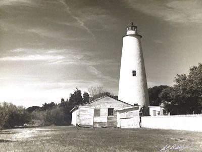
The second-oldest lighthouse in North Carolina, Ocracoke Lighthouse is celebrating its 200th birthday in 2023! The 75-foot, whitewashed tower and its...read more
There are many theories about how ponies found their way to Ocracoke Island. Some say they arrived on English ships during 16th-century exploration, others...read more